Archive for Parks

Walk Highlights, Part 2: Parks

Picking favorite parks is tough when there are over 50 to choose from in Berkeley! Here my choices are based on the parks that I found most enjoyable as a walker. My selections would be different if I was picking what I think are the most successful parks from an urban planning standpoint (i.e., design and layout, placement, activities, safety, etc.). Again, in no particular order:

John Hinkel Park: Entering this park for the first time, I had one of the many moments on this walk where I decided that it was worthwhile to walk each and every street. Unless I lived near this park, I might not have realized it was there. I had the feeling of being far away from anything urban — creeks flowing, lots of vegetation, and crisscrossing trails through the park. Also of interest here is the amphitheater that has been the site of the Berkeley Shakespeare Festival.

Rock Parks: There are several rock parks in the Thousand Oaks area, which can be combined with several of the Berkeley paths for a very nice walk. This is a great place to bring visitors to show them a unique part of Berkeley. One of my blog entries from last year has a few more details about the rock parks, and the Berkeley Path Wanderers has a nice suggested route, with history, for visiting these parks.

Live Oak Park: This is a great park to plan into a walk as a place to take a break and look around for awhile. It includes a restored stone fireplace in the picnic area, the Berkeley Art Center, a nice places to stroll along the creek and through the trees. From Downtown Berkeley BART, walk north on Shattuck and on to Berryman Path to walk through the park. Just a few blocks from Live Oak Park is the Berkeley Rose Garden and Codornices Park (with a waterfall!), which make a nice combined walk.

Ohlone Park: This park, which extends from Sacramento St. to Milvia St., between Hearst and Delaware, offers a lot to look at for the walker: playing fields, basketball court, community garden, off-leash dog area, an Ohlone history mural, and play areas. From North Berkeley BART (crossing Sacramento at Delaware), it’s a nice flat stroll along the Ohlone Greenway paralleling Ohlone Park. At the end of the Greenway, continue to straight for a couple of blocks to visit the UC Berkeley campus, or turn right on Shattuck to get to the downtown Berkeley BART.

Strawberry Creek Park: I really enjoy walking through this park because it affords an opportunity to visit the Strawberry Creek Design Center (more on this in a separate Highlights post). The park also include native plants, and recreation areas and courts. The Santa Fe Right of Way runs through this park, which will be particularly nice for walking once a connecting block is opened between University and Addison through the Montessori school. Next to this park is the Berkeley Lawn Bowling Green, which offers free lessons on Wednesday and Saturday mornings. For a Saturday morning walk from Downtown Berkeley BART, head from BART through the Saturday Farmer’s Market (starts at 10 a.m.) on Center Street, cross southwest through Cesar Chavez Park to Allston, continue Allston past Presentation Park and across Sacramento, left at Acton to the Lawn Bowling Green to view the bowlers in action, right on Bancroft and right into Strawberry Creek Park at the Santa Fe Right of Way path. This can also be combined with a visit to Ohlone Park (listed above) to make a loop back to where you started.

King School Park: For the same reasons that I like Hopkins Street, which I mentioned in my commercial area favorites), I enjoy walking past the nearby King School Park. In the early evening and on weekends, this park is busy with people playing tennis, jogging on the track, walking dogs, and chatting with neighbors. A nice loop walk that includes this park is Sacramento, Hopkins, The Alameda/MLK, and Rose streets. You’ll see the King School Park, the North Berkeley Public Library, the Edible Schoolyard (at King School), and the Hopkins Street commercial district.

John Muir School Park: Another school park, but this one is quite different than King School. The best way to explore this park is by walking the Oakridge Path between Claremont and Domingo avenues. Harwood (Claremont) Creek runs through the park, and you’ll see native plantings and restoration work done by the children from the school. There’s also a very nice school vegetable garden here.

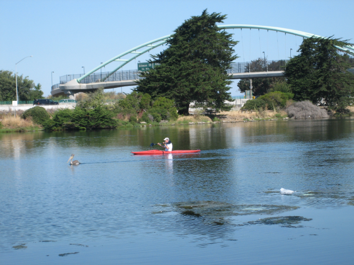
Berkeley Marina (includes Shorebird Park, Cesar Chavez Park, Horseshoe Park, and the Adventure Playground): Technically this is divided into a few parks, but most people will visit through more than one of them on a trip out there. Some highlights include a straw bale environmental education building (Shorebird Park), tools and building actitivies for children (Adventure Playground), great views on the loop around Cesar Chavez park, and the long fishing pier (which can be walked out to the end). If you are up for a long but flat walk, take the I-80 pedestrian/bike bridge (accessed at the foot of Addison Street) over to the Marina. On the Marina side of the bridge is the Sea Breeze Cafe, a good store for some coffee or refreshments for the walk. A visit to the Berkeley Marina would be an ideal outing for someone coming into Berkeley on Amtrak, whose station is situated a block from the bike bridge under the University Avenue overpass.

Comments (2)

More on Parks


A couple of weeks ago I finally started reading a book that had been on my list for years now, Jane Jacobs’ The Death and Life of Great American Cities. If you read anything related to city planning, neighborhoods, community, and the like, it will likely contain quotes from this book. I am only about a third of the way through, mainly because it so though-provoking that I am finding it easier to read it in small pieces. Now this book is about large cities, but it is still interesting to think about Jacobs’ ideas and how they apply to a smaller city like Berkeley. After reading the book’s chapter on parks, I spent some time thinking about all of the parks I have visited while walking throughout Berkeley. The first thing I had observed while walking is that Berkeley has quite a few parks for a small city; I think most of my walks ended up passing at least one park, if not a few. Second, Berkeley has a mix of general use and specialized parks. Some of the specialized uses include the Adventure Playground (tools and building experiences for children), boating at the Aquatic Park, kite flying at Cesar Chavez Park, bouldering and rock climbing at the rock parks, skateboarding ramps at Harrison Park, and off-leash dog areas at Cesar Chavez and Ohlone parks. Playing fields and courts for various sports are available at several parks.

Despite my observations about lots of people being out and about at all times of the day in Berkeley, I have found that most of the parks are not filled with people all day long. The city has several “tot lots,” which are small parks with playground equipment, but many are fairly empty during the daytime hours. One exception is Virginia-McGee Totland, which has a huge selection of toys and play equipment and seems to be packed with children and parents all day long. Totland may explain part of the absence of crowds at the other parks (it definitely appears that people come to Totland from other neighborhoods to for the social and play opportunities), as does the great number of children who go to pre-school these days. Adults who have leisure time during the day are more likely to be at the numerous cafes around town. Would this change if wireless Internet access where available throughout town? And what if there where coffee carts located at or within a block of some of the parks? The Sea Breeze Market/Deli is a good example of this in Berkeley, as it is a nice coffee and snack stop for cyclists and walkers coming over the bicycle bridge and to the Berkeley Marina, (although many people also stop there in their cars getting off the freeway, and then drive the rest of the way to the Marina). In San Francisco, I’ve witnessed many people picking up some coffee at the Blue Bottle Coffee kiosk in San Francisco and taking it over to the Hayes Green (which I highly recommend visiting if you are interested in successful parks/public commons).

I don’t walk through parks at night, but during the day most of the Berkeley parks I visited seemed safe. One park, Greg Brown, has limited hours and has been locked up when I have walked in the neighborhood. It is pretty secluded, and I imagine the closing is due to concerns about drug dealing and other illegal activity in the park after dark. Previously I had mentioned my concerns about safety at the Aquatic Park. After reading Jacobs’ writing about parks, I realized that the location of the park has much to do with this. Because it is at the waterfront near the edge of the city, you don’t walk through the park to get to anything else. The railroad tracks further isolate the park because it cannot be accessed at every east-west street it intersects. It will be interesting to see what happens at the south end of the Aquatic Park once the West Berkeley Bowl opens a few blocks away and brings lots of people to the area at all hours of the day. Will more people visit or will they not even realize there is a park a few blocks away?

If you are interested in learning more about some of the parks I have mentioned here and in past entries, Berkeley Partners for Parks has organized a series of events to celebrate the centennial of the city’s parks. This Sunday, a fundraiser will be held at the Aquatic Park, and there will be an opportunity that day to walk at future site of the labyrinth that the East Bay Labyrinth project hopes to build, and a fall equinox celebration at Cesar Chavez Park’s solar calendar. Other park events will be happening through mid-November and are listed on the website’s calendar. Another fun project for learning about the parks and city would be to visit a different Berkeley park each week; conveniently Berkeley has 52 official parks! Even if you have been to all of the parks, I recommend visiting them again and at different times of the year. You never know what interesting things you will find, such as the strange scene (pictured below) that I came upon last year, at Oak Park, with a felled oak tree!


Photo by Joe Reifer

Comments (3)

Aquatic Park


Berkeley Peace Lantern Ceremony, photo by Joe Reifer

I was just marking my calendar for the Berkeley Peace Lantern Ceremony, which is held in early August to commemorate the Hiroshima atomic bombing. Attendees of the event make paper lanterns, which are sent afloat at the Berkeley Aquatic Park. There are also music and speeches, and in the past I have enjoyed attending this event. I realized as I noted the event that I had not written yet about the Aquatic Park. If you’re not familiar with Berkeley, the Aquatic Park is located in southwest Berkeley on the east side of I-80. At the north end of the Aquatic Park is the bicycle bridge, connecting to the Berkeley Marina. The Parks dept. map shows it pretty well (blue at bottom left).

Because I am including paths in my walk, I have walked around the Aquatic Park on the walk/bike path. The east side is nice (but watch out for flying objects — there’s a disc golf course along this side), but the west side was not as pleasant; you are walking right next to the freeway wall with the sounds and smells of cars and trucks whizzing by. This side is really best travelled by bicycle in my opinion. On the water itself, I have seen rowing and canoeing. There is a water ski ramp, but I have not actually seen anyone using it yet. The Aquatic Park was a Works Progress Administration (WPA) project build in the 1930s; its existence was apparently threatened in 1963 when developers wanted to fill it in and make it into a business park.

Although I like the Aquatic Park and its amenities, it seems in need of some upgrades — particularly those that would make it a bit safer. Although the park is pleasant and filled with people (joggers, dog walkers, picnickers, children, etc.) on weekends and after work, I’m not inclined to walk by myself along this path at non-busy times — especially because there seem to be shrubbery and other places where people could lurk, and I have also noted people just sitting and waiting in their cars at the south end of the park. Berkeley has big plans in place for streetscape improvements along the route from the Fourth Street shopping area and the Amtrak station to the Aquatic Park and bicycle bridge. It looks the improvements will mostly occur around the north area of the park near the bridge, but perhaps this will increase the amount of foot traffic and safety in the area a bit.

Comments (7)

Street to Trail

After first moving to Berkeley, a friend gave us a copy of East Bay Out, a guide to the East Bay parks written by Malcolm Margolin. The book was published in 1988, so it is probably not the best guide to use on its own when hiking in one of the parks, but I highly recommend it nonetheless. The writing is great, and it provides quite a bit of interesting natural history of the area. Although I wanted to eventually explore all of the parks listed in the book, the description of Claremont Canyon stood out to me because of its proximity to the streets of Berkeley. A couple of months later I walked behind UC Berkeley’s Clark Kerr campus and found the entrance to the steep trail up the hill. Not having a map of the area, I wasn’t sure how far the trails went, but I could see that there was more out there that I hadn’t explored.

This Sunday, after a short but strong rainstorm the night before, I set out to walk some of the streets at the back of the Berkeley campus that I had not yet tackled — Stadium Rim Way, Centennial Drive, and some of the surrounding streets. Sunday turned out to be a big sporting event day at the campus; there was a rugby game, soccer, people using the sports fields and facilities, lots of people and loudspeakers. Usually my Sunday mornings are pretty quiet, so I was a bit surprised by all of the activity, and it was a little bit of a relief to suddenly jump onto a dirt fire road off Centennial Drive. The trails here run along and then away from Strawberry Creek, and intersect with the Claremont Canyon trails. Eventually I was popped out on the street again, near all of the fraternities and sororities and lots of activity again. It was sort of a shocking and fun experience to go from lots of noise and activity to trees and water, then back to all of the activity again.I really like the idea of being able to access trails easily just by walking off the city street and onto the trail. If you live in the Berkeley Hills, Tilden Park can be accessed easily from the street, as I mention in my post about Tilden a couple of months ago. However, the Strawberry Canyon and Claremont Canyon trails are even more available because of their proximity to Downtown Berkeley BART. In fact, I found a very nice self-guided tour of these areas written by the Greenbelt Alliance. I plan on going back soon with to do their variation on the walk with the added historical details.

Comments (2)

Walking Near Tilden Park

The northeast boundary of Berkeley and of the area I am walking is Tilden Park. I originally thought that my walk of every street and pathway of Berkeley might include Tilden, but the park is actually located in unincorporated Contra Costa County. Although I like Tilden and its hiking trails, I am grateful that I do not need to walk the roads in the 2000-acre park, many of which are pretty hazardous for the pedestrian. Tilden offers hiking opportunities on a variety of levels — everything from a pleasant flat stroll to a strenuous trek up to Wildcat Peak or Vollmer Peak, plus a swimming lake, picnic areas, trails open to mountain bikes, steam trains, a botanic garden, a farm and environmental education center, and more. I have been pleased to learn from walking near the Tilden border that the park and its amenities are more accessible without a car than many other Bay Area hiking areas. For one, the 67 AC Transit bus runs every half hour or so from downtown Berkeley BART up through the park on weekends, and near the entrance on weekdays (line 65 also comes within a few blocks of the park). I also found that there a number of other ways to pop onto to trails in Tilden from the surrounding neighborhoods. This has been one of my favorite parts of walking near Tilden; to be strolling down the street and suddenly see a trail entrance.

A few days ago I was reading an article in the Chronicle about the Berkeley State of the City address, one of the focuses of which was a vision for a more environmentally sustainable Berkeley. In the article, one Berkeley councilmember was quoted as saying that the environmental goals were “very optimistic”; “It’s going to be very hard to change people,” she said. “In my district alone, we’ve got to stop people driving up and down the hill four or five times a day.” This statement reminded me of the observation that I have found that the most unpleasant streets for walking are not just near the freeway entrances. Cedar, Hopkins, and Marin are particularly car-choked, especially on weekdays from about 2:30 on, as people pick up children from school, run errands, and come home from work. These streets seems to have a constant stream of traffic as the main thoroughfares from the Highway 80 and the flatland areas of Berkeley up into the almost entirely residential Berkeley hills.

I am not the best person to come up with ideas for getting people to drive less and reducing the amount of traffic in the hills. My idea of what is doable in terms of walking is unreasonable for most people, and it is not my place to make judgments about how people use their time or the decisions they make about how they go about their lives. I have often thought that one area where traffic could be reduced is trips to parks and hiking areas. What if, for instance, shuttles (run on alternative fuel) ran every 15-20 minutes or so from transit hubs (such as BART or Caltrain stations) or downtown areas of Bay Area cities to the various city/county/regional/state parks? If you made it easy and pleasant, some people might be willing to leave the car at home rather than drive up winding roads and worry about finding a parking spot at the park. Realistically and logistically, this isn’t likely to happen anytime soon, so we have to make do with what is available. I hope eventually to research the best car-free ways to get to parks and recreation areas in the Bay Area, as it is often confusing to figure out and sometimes involves two or three different transit agencies. Tilden, luckily, is fairly straightforward and not too much of a hassle if you live in Berkeley or near BART. I also want to know what the shortest route on foot is from a the North Berkeley and downtown BART stations to Tilden. One of the nice things about Berkeley’s stairways is that a pleasant walk could be had up the various stairways from the flatlands to the park, avoiding some of the steep and winding streets.

Comments (3)

Recreation

Lots of excitement here over the past few days. First of all, the traffic light is now functioning at University Ave. end of the newly paved section of the Santa Fe Right-of-Way. I happened to be there during the morning commute and school drop-off time, when University (a major thoroughfare) was busy and it was raining a bit. I pushed the button, and sure enough the light turned and traffic stopped. I was anticipating some surprise due to the newness of the light and its placement between intersections, but no cars came skidding to a stop. And if this wasn’t exciting enough, a few days ago I finally saw someone using the Parcourse along the Ohlone Greenway. I refrained from asking the man questions about whether this was a regular routine, how he dealt with the broken exercise stations, etc., because he looked intent on exercising. This reminded me that I had a couple of other things I wanted to point out recreation-wise in Berkeley.


Photo by Joe Reifer

Recreation facilities in Berkeley include the typical soccer fields, basketball courts, baseball and softball diamonds, as well as skateboard parks, Frisbee golf, and a lawn bowling green. I have seen other lawn bowling greens in the Bay Area and elsewhere, but I particularly like the one in Berkeley. I was looking for a website for the lawn bowling club, which I did not find. However, I did turn up an interesting page on the club from an activist website. It seems that a bit of controversy surrounded the green in the 1970s regarding the use of some of the bowling green land for construction of a tot lot. Quite a few references were made to clashes between the rich “hill people” who used the greens and the lower and moderate income “flatlanders” in the neighborhood of the bowling green. I haven’t heard of any issues with the greens these days.

A couple of months ago I was cutting through the old Berkeley Adult School campus and heard some music off in the distance. Turning the corner, I found a water aerobics class in session! It looked like a lot of fun, and I was all ready to sign up right there until I found out that it was for seniors only. Berkeley has a few pools and aquatics programs, and offers lessons, lap swimming, and programs for disabled swimmers. And speaking of disabilities, I spent some time recently looking at Ann Sieck’s wonderful website for wheelchair accessible trails in the Bay Area. Her website includes listings for Berkeley, describing wheelchair accessibility at UC Botanical Garden, Cesar Chavez Park, and Tilden Park. A very useful resource!

Comments (2)

Berkeley for Children


Photo by Joe Reifer

On Halloween last week I walked across town to a party during the time when all of the trick-or-treaters were out and about. I know there are lots of children in Berkeley, but I was surprised at the sheer number of children in neighborhoods (such as near the Berkeley campus) where I did not expect that many lived. On many of my walks I have taken note of all sorts of things that children can do here in Berkeley, but I have found this to be an area where it was challenging to stay neutral about the observations. As most people do, I have preconceived ideas (based on my childhood and my opinions as an adult) about what makes somewhere a good place to grow up. I am usually perplexed by and somewhat skeptical about the “best places to raise a family” lists published by various media outlets and polling organizations because they are often so subjective; everyone puts different weights on criteria ranging from quality of schools to crime level, housing affordability, and availability of services and opportunities specific to the needs of their children (such as health care for a particular condition or strong arts and sports programs). I can’t make too many comments about these factors on my walks anyway, but I can report on what I have seen for children around town. There are lots of parks and playgrounds throughout town with typical play equipment and structures. Virginia-McGee Totland has much more than the average in the way of toys and structures, and the Adventure Playground has a unique setup with hammers, lumber, paints, and opportunities for children to build and create. There are public swimming pools, and several parks have basketball and tennis courts, recreation centers, and fields for baseball, softball, and soccer. Tilden Park, in the Berkeley hills, has a merry-go-round, animal farm and nature area, a lake for swimming, a steam train, picnic areas, and hiking trails. Berkeley Iceland offers ice skating and hockey opportunities. In the way of culture and learning, there is a children’s museum, the Hall of Health, the Berkeley Art Museum, and other museums on the Berkeley campus. I am sure there will be even more to see as I continue to walk new streets.

Two Berkeley women maintain a blog called Rookie Moms that has the goal of offering 365 activities for new parents. I have to admit that before I looked through it I wondered if it was just going to be a resource for parents who have lots of money to spend on themselves and their babies, but I was pleasantly surprised to find that this wasn’t entirely the case. Their Week in Berkeley section conveniently lists a variety of activities and notes the cost in cases where there is one. If you look at the blog entries tagged free/cheap and Berkeley, you’ll find all sorts of other interesting ideas, including library story times, nice places to walk with a stroller, “tiny tot” swimming lessons, and more. For those with money to spend, there are suggestions for baby- and child-friendly places to eat, classes, and services for parents.

No, I have not forgotten about schools, but I will talk about that in a separate post in the future because there are quite a few points to cover there.

Comments (3)

A Good Idea at the Time


Though I understand the reasons why some people prefer to walk indoors at the gym on a treadmill, I would be bored out of my mind in under 5 minutes of walking on that giant conveyor belt staring outside where I could be walking. Of course most gyms have many more options for exercise, but they are also fairly expensive. One of the nice benefits of walking outside, in addition to all of the interesting experiences, is getting a bit of exercise along the way. No sign-up fee and monthly charges. If I wanted more exercise on a walk and was creative, I could come up with other ways to exercise for free. Walk to a local track for some laps. Run up stairs. Stop at a park and do some stretching exercises on the lawn. But the option that intrigues me the most is the outdoor fitness course (commonly known by the brand name Parcourse). The Parcourse is a set of exercise stations set along a path or trail. There might be sit-ups, pull-ups, a balance beam, and others, along with instructional signs. You would do an exercise, walk or jog to the next station, and so on until the end. Growing up in the suburban Bay Area, I remember the popularity of the Parcourse. As this article from Outside magazine notes, the Parcourse peaked in the mid-1980s and then faded from popularity.

I still think the Parcourse was a great idea, but it appears to have faded here in Berkeley as with other places. I have seen Parcourses out at the Berkeley Marina, at the Aquatic Park, and along the Ohlone Greenway. I tried on a few occasions to do the Parcourse circuit, and failed mostly because the stations were damaged. The station I show here is actually still usable despite the missing sign, but in other cases crucial parts of the equipment were missing. On the Ohlone Greenway, there are at least two, if not more different Parcourses, and I got really confused trying to find the next station in a particular course. My best guess is that they were funded and installed by different cities along the Greenway. Also (thought while doing jumping jacks alone, as cars and people passed by), many people would probably be less self-conscious and more motivated to do the Parcourse if others were doing it along with them. Berkeley has many “Friends of” groups for parks, trails, creeks, etc., but it does not appear that anyone has yet organized a “Friends of the Berkeley Outdoor Fitness Courses” group.

Comments (2)

Rock Parks & More Science Mysteries


Photo by Joe Reifer

Walks in the Berkeley hills seem to be generating quite a few research questions of the scientific sort. One of the highlights of walking in the Berkeley hills is the rock parks — such as Indian Rock Park and Great Stoneface Park — which are city parks that feature rock outcrops that are popular with climbers who want to practice their skills without the cost of going to a climbing gym, and with others who enjoy views across the Bay. I had already visited some of the rock parks in the past, but was surprised to find big rocks in other places in the Thousand Oaks area beyond the parks. Like right in people’s front yards.

As luck would have it, a book about these rocks (which are called Northbrae rhyolite) is due out later this year. It is aptly called Berkeley Rocks. Needless to say, I am pretty excited to see the book, and you can expect a review here when it comes out. In the meantime, a little more about these rocks can be found in a San Francisco Chronicle article from last year, which notes the incorporation of the rocks with architecture of the surrounding houses. Apparently hundreds of homes in the area have rock in their yards. The Berkeley Path Wanderers route sheet for a walk of the rock parks also contains more details about area’s geology.

Comments (4)

Dog-friendly Berkeley

I do not have a dog, but I feel confident that if I did have one here in Berkeley that I would not need a car for the dog to get plenty of exercise. Officially, there are two off-leash dog parks in Berkeley, one at Ohlone Park (apparently the first dog park in the world) and the other at Cesar Chavez Park out at the Marina, but on my walks I have seen plenty of dogs off-leash in other parks. Dogs are also allowed (on leash) in most hiking trails in Tilden Park.

In business districts, many stores allow dogs or leave water dishes outside for waiting dogs. The Fourth Street area that I mentioned in my last post seems to be the most dog-friendly shopping area, and is home to an upscale dog boutique. Several blocks away, on San Pablo, the Albatross Pub welcomes dogs inside before 8 pm. The hip dog magazine The Bark is based in West Berkeley, and dogs and their volunteer walkers can regularly be spotted near the Berkeley-East Bay Humane Society.

Comments (5)

Older Posts »